• The Ottoman Empire at Its Greatest Extent

    At its height, the Ottoman Empire was one of the most powerful states in world history, spanning large parts of Southeastern Europe, Western Asia, and North Africa.

    A Transcontinental Empire

    The empire controlled territories surrounding much of the Mediterranean, Black Sea, and Red Sea, creating a strategic bridge between Europe, Asia, and Africa.

    Major Regions Under Ottoman Rule

    Anatolia — the Ottoman heartland
    The Balkans — extensive territories across Southeastern Europe
    Greece — much of the region was incorporated into the empire at different periods
    The Levant — including Syria and surrounding territories
    Mesopotamia — major Ottoman territories in present-day Iraq
    Egypt — an important economic and strategic province
    North Africa — Ottoman territories along much of the southern Mediterranean
    The Arabian Peninsula — including the Hejaz and other regions
    The Caucasus — areas contested and controlled at different times

    Key Facts

    Istanbul (Constantinople) became the imperial capital after the Ottoman conquest of 1453.
    At its height, the empire controlled territories across three continents.
    The Mediterranean Sea, Black Sea, Red Sea, and major land routes were strategically important to Ottoman power.
    The empire ruled over a remarkable diversity of peoples, languages, religions, and cultures.
    Ottoman influence lasted for more than six centuries, from its foundation around the end of the 13th century until its dissolution in the early 20th century.

    From a Frontier State to a Global Power

    What began as a small Anatolian principality developed into a vast empire that became a major political and military power between Europe, Asia, and Africa.

    The Ottoman Empire was not simply a European or Asian empire—it was a truly transcontinental power.

    #OttomanEmpire #OttomanHistory #History #Geography #WorldHistory
    🕌 The Ottoman Empire at Its Greatest Extent At its height, the Ottoman Empire was one of the most powerful states in world history, spanning large parts of Southeastern Europe, Western Asia, and North Africa. 🌍 A Transcontinental Empire The empire controlled territories surrounding much of the Mediterranean, Black Sea, and Red Sea, creating a strategic bridge between Europe, Asia, and Africa. 🗺️ Major Regions Under Ottoman Rule 🇹🇷 Anatolia — the Ottoman heartland 🌍 The Balkans — extensive territories across Southeastern Europe 🇬🇷 Greece — much of the region was incorporated into the empire at different periods 🇸🇾 The Levant — including Syria and surrounding territories 🇮🇶 Mesopotamia — major Ottoman territories in present-day Iraq 🇪🇬 Egypt — an important economic and strategic province 🌍 North Africa — Ottoman territories along much of the southern Mediterranean 🕌 The Arabian Peninsula — including the Hejaz and other regions ⛰️ The Caucasus — areas contested and controlled at different times ⚔️ Key Facts 🔹 Istanbul (Constantinople) became the imperial capital after the Ottoman conquest of 1453. 🔹 At its height, the empire controlled territories across three continents. 🔹 The Mediterranean Sea, Black Sea, Red Sea, and major land routes were strategically important to Ottoman power. 🔹 The empire ruled over a remarkable diversity of peoples, languages, religions, and cultures. 🔹 Ottoman influence lasted for more than six centuries, from its foundation around the end of the 13th century until its dissolution in the early 20th century. 🏛️ From a Frontier State to a Global Power What began as a small Anatolian principality developed into a vast empire that became a major political and military power between Europe, Asia, and Africa. The Ottoman Empire was not simply a European or Asian empire—it was a truly transcontinental power. #OttomanEmpire #OttomanHistory #History #Geography #WorldHistory
    0 Σχόλια 0 Μοιράστηκε
  • TURKEY: A COUNTRY CONNECTING EUROPE AND ASIA

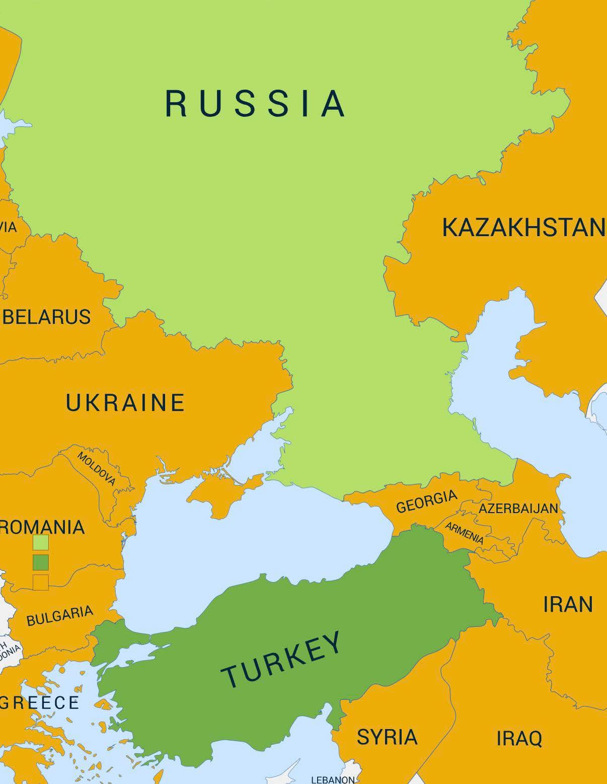
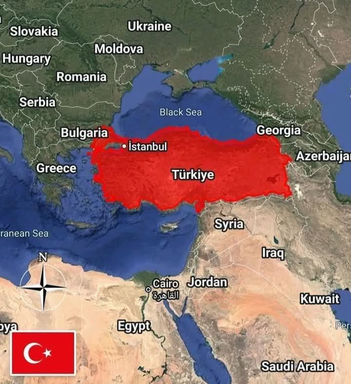
    Turkey occupies a strategic position between Europe and Asia, with coastlines along the Black Sea, Aegean Sea, and Mediterranean Sea.

    It shares land borders with 8 countries, stretching from the Balkans to the Caucasus and the Middle East.

    Turkey’s Land Borders:

    Syria — 911 km
    Iran — 534 km
    Iraq — 367 km
    Armenia — 328 km
    Georgia — 273 km
    Bulgaria — 259 km
    Greece — 206 km
    Azerbaijan — ~17 km via Nakhchivan

    Key Facts

    Capital: Ankara
    Area: ~783,562 km²
    Population: ~86 million
    Official language: Turkish
    Currency: Turkish lira
    Highest peak: Mount Ararat — 5,137 m
    Government: Presidential republic
    Location: Europe & Asia
    Seas: Black Sea, Aegean Sea & Mediterranean Sea

    Did you know Turkey shares land borders with 8 countries?

    #Turkey #Geography #WorldMap #Europe #Asia
    🇹🇷 TURKEY: A COUNTRY CONNECTING EUROPE AND ASIA 🌍 Turkey occupies a strategic position between Europe and Asia, with coastlines along the Black Sea, Aegean Sea, and Mediterranean Sea. It shares land borders with 8 countries, stretching from the Balkans to the Caucasus and the Middle East. 🗺️ Turkey’s Land Borders: 🇸🇾 Syria — 911 km 🇮🇷 Iran — 534 km 🇮🇶 Iraq — 367 km 🇦🇲 Armenia — 328 km 🇬🇪 Georgia — 273 km 🇧🇬 Bulgaria — 259 km 🇬🇷 Greece — 206 km 🇦🇿 Azerbaijan — ~17 km via Nakhchivan 📌 Key Facts 🏙️ Capital: Ankara 📐 Area: ~783,562 km² 👥 Population: ~86 million 🗣️ Official language: Turkish 💰 Currency: Turkish lira ⛰️ Highest peak: Mount Ararat — 5,137 m 🏛️ Government: Presidential republic 🌍 Location: Europe & Asia 🌊 Seas: Black Sea, Aegean Sea & Mediterranean Sea 💬 Did you know Turkey shares land borders with 8 countries? #Turkey #Geography #WorldMap #Europe #Asia
    0 Σχόλια 0 Μοιράστηκε
  • Asia and Africa together are home to the overwhelming majority of the world's Muslim population.

    With 1.3 billion in Asia and 500 million in Africa, these two continents account for nearly the entire global total — while North America, South America, and Australia combined make up less than 15 million.

    As the infographic notes, these figures are approximate and vary by source and year.

    Which region's number stood out most to you?

    #GeoMystic #Population #WorldReligions #geography #muslim
    🕌 Asia and Africa together are home to the overwhelming majority of the world's Muslim population. With 1.3 billion in Asia and 500 million in Africa, these two continents account for nearly the entire global total — while North America, South America, and Australia combined make up less than 15 million. As the infographic notes, these figures are approximate and vary by source and year. Which region's number stood out most to you? 👇 #GeoMystic #Population #WorldReligions #geography #muslim
    0 Σχόλια 0 Μοιράστηκε
  • THE OTTOMAN EMPIRE

    The Ottoman Empire was one of the longest-lasting and most influential empires in world history, existing for more than 600 years, from 1299 to 1922.

    Origins: Founded by Osman I in the late 13th century, it began as a small principality in Anatolia and gradually expanded into a powerful empire.

    Greatest Expansion: At its height, the empire controlled vast territories across Southeastern Europe, Western Asia, the Middle East and North Africa, connecting three continents.

    Capital: After the conquest of Constantinople in 1453, the city became the political and cultural center of the empire. It is known today as Istanbul.

    Strategic Position: Ottoman territories surrounded major waterways and trade routes, including the Mediterranean Sea, Black Sea and Red Sea, giving the empire enormous geopolitical importance.

    Legacy: The Ottoman Empire left a lasting impact on architecture, culture, cuisine, art, politics and the history of numerous countries across Europe, Asia and Africa.

    From a small Anatolian principality to a vast transcontinental empire, the Ottoman Empire played a major role in shaping the history of three continents.

    #OttomanEmpire #WorldHistory #HistoryFacts #HistoricalMaps #Geography #Empire #Istanbul #History
    🏛️ THE OTTOMAN EMPIRE The Ottoman Empire was one of the longest-lasting and most influential empires in world history, existing for more than 600 years, from 1299 to 1922. 🔹 Origins: Founded by Osman I in the late 13th century, it began as a small principality in Anatolia and gradually expanded into a powerful empire. 🔹 Greatest Expansion: At its height, the empire controlled vast territories across Southeastern Europe, Western Asia, the Middle East and North Africa, connecting three continents. 🔹 Capital: After the conquest of Constantinople in 1453, the city became the political and cultural center of the empire. It is known today as Istanbul. 🔹 Strategic Position: Ottoman territories surrounded major waterways and trade routes, including the Mediterranean Sea, Black Sea and Red Sea, giving the empire enormous geopolitical importance. 🔹 Legacy: The Ottoman Empire left a lasting impact on architecture, culture, cuisine, art, politics and the history of numerous countries across Europe, Asia and Africa. 🌍 From a small Anatolian principality to a vast transcontinental empire, the Ottoman Empire played a major role in shaping the history of three continents. #OttomanEmpire #WorldHistory #HistoryFacts #HistoricalMaps #Geography #Empire #Istanbul #History
    0 Σχόλια 0 Μοιράστηκε
  • Can you believe that Europe and Asia are just 700 meters apart in Istanbul?!

    Yes — less than one kilometer separates two continents at one of the most fascinating geographical points on Earth.

    This is the Bosphorus Strait, which divides Istanbul between its European and Asian sides, making the city one of the few major cities in the world located on two continents.

    Amazing Bosphorus Facts:
    • Length: About 31 km
    • Narrowest point: About 700 m
    • Widest point: Up to 3.7 km
    • Depth: Over 100 m in some areas
    • North: Black Sea
    • South: Sea of Marmara

    But the Bosphorus is far more than a geographical boundary. It is a vital international waterway connecting the Black Sea with the Sea of Marmara, and providing a maritime route toward the Aegean and Mediterranean seas.

    This extraordinary location gives Istanbul something very few cities can claim:

    One city. Two continents. One legendary strait.

    Here’s the question:

    If you were standing on one side of the Bosphorus looking across at the other…

    Would you feel like you were looking at another continent or simply another part of the same city?

    Europe or Asia?
    Which side would you choose to explore first — and why?

    #Geography #BosphorusStrait #Istanbul #Turkey #AsiaAndEurope
    🌍 Can you believe that Europe and Asia are just 700 meters apart in Istanbul?! Yes — less than one kilometer separates two continents at one of the most fascinating geographical points on Earth. 📍 This is the Bosphorus Strait, which divides Istanbul between its European and Asian sides, making the city one of the few major cities in the world located on two continents. 📏 Amazing Bosphorus Facts: • Length: About 31 km • Narrowest point: About 700 m • Widest point: Up to 3.7 km • Depth: Over 100 m in some areas • North: Black Sea • South: Sea of Marmara 🚢 But the Bosphorus is far more than a geographical boundary. It is a vital international waterway connecting the Black Sea with the Sea of Marmara, and providing a maritime route toward the Aegean and Mediterranean seas. 🏙️ This extraordinary location gives Istanbul something very few cities can claim: One city. Two continents. One legendary strait. 🔥 Here’s the question: If you were standing on one side of the Bosphorus looking across at the other… Would you feel like you were looking at another continent or simply another part of the same city? 🇪🇺 Europe or 🌏 Asia? Which side would you choose to explore first — and why? #Geography #BosphorusStrait #Istanbul #Turkey #AsiaAndEurope
    0 Σχόλια 0 Μοιράστηκε
  • 15 Interesting Facts About Türkiye

    Top Tourist Destination
    Türkiye is consistently among the Top 10 most visited countries in the world, attracting 50+ million international tourists annually.

    Largest City
    The biggest city is Istanbul, with 16+ million people, making it one of the largest cities in Europe.

    Capital City
    The capital is Ankara, located in central Anatolia.

    Population Power
    Türkiye has a population of about 85 million people, making it one of the most populous countries in Europe and the Middle East.

    Unique Geographic Location
    Türkiye sits between Europe and Asia, connected by the Bosphorus strait.

    Large Economy
    Türkiye has one of the largest economies in the world, usually ranking around Top 20 globally by GDP.

    Major Tourist Cities
    Popular tourist destinations include:
    • Istanbul
    • Antalya
    • Izmir
    • Bodrum
    • Cappadocia region.

    Ancient Civilization Center
    Türkiye has hosted many civilizations including the Hittites, Greeks, Romans, Byzantines, and Ottoman Empire.

    World Heritage Sites
    Türkiye has 19 UNESCO World Heritage Sites, including Göbekli Tepe, one of the oldest temples in the world (11,000+ years old).

    Agricultural Power
    Türkiye is one of the world’s largest producers of hazelnuts, apricots, figs, and cherries.

    Strategic Straits
    The Dardanelles and Bosphorus connect the Black Sea to the Mediterranean Sea.

    Huge Airline Hub
    Turkish Airlines flies to more countries than any other airline in the world.

    Beautiful Coastline
    Türkiye has about 8,300 km of coastline along the Black Sea, Aegean Sea, and Mediterranean Sea.

    Famous Cuisine
    Turkish cuisine includes global favorites like Kebab, Baklava, and Turkish Delight.

    Historic Megacity
    Istanbul is the only city in the world located on two continents.

    ⸻

    Türkiye Facts
    Top 10 most visited country in the world
    Population: ~85 million
    Largest city: Istanbul (16M+)
    Bridge between Europe & Asia
    Top 20 global economy
    19 UNESCO World Heritage sites
    Major agricultural exporter
    Turkish Airlines flies to most countries worldwide
    8,000+ km coastline
    World-famous cuisine

    #turkiye #turkey #geography #worldfacts #europe #asia #travel #amazingworldgeography #fblifestyle
    🇹🇷 15 Interesting Facts About Türkiye 🌍 1️⃣ Top Tourist Destination Türkiye is consistently among the Top 10 most visited countries in the world, attracting 50+ million international tourists annually. 2️⃣ Largest City The biggest city is Istanbul, with 16+ million people, making it one of the largest cities in Europe. 3️⃣ Capital City The capital is Ankara, located in central Anatolia. 4️⃣ Population Power Türkiye has a population of about 85 million people, making it one of the most populous countries in Europe and the Middle East. 5️⃣ Unique Geographic Location Türkiye sits between Europe and Asia, connected by the Bosphorus strait. 6️⃣ Large Economy Türkiye has one of the largest economies in the world, usually ranking around Top 20 globally by GDP. 7️⃣ Major Tourist Cities Popular tourist destinations include: • Istanbul • Antalya • Izmir • Bodrum • Cappadocia region. 8️⃣ Ancient Civilization Center Türkiye has hosted many civilizations including the Hittites, Greeks, Romans, Byzantines, and Ottoman Empire. 9️⃣ World Heritage Sites Türkiye has 19 UNESCO World Heritage Sites, including Göbekli Tepe, one of the oldest temples in the world (11,000+ years old). 🔟 Agricultural Power Türkiye is one of the world’s largest producers of hazelnuts, apricots, figs, and cherries. 1️⃣1️⃣ Strategic Straits The Dardanelles and Bosphorus connect the Black Sea to the Mediterranean Sea. 1️⃣2️⃣ Huge Airline Hub Turkish Airlines flies to more countries than any other airline in the world. 1️⃣3️⃣ Beautiful Coastline Türkiye has about 8,300 km of coastline along the Black Sea, Aegean Sea, and Mediterranean Sea. 1️⃣4️⃣ Famous Cuisine Turkish cuisine includes global favorites like Kebab, Baklava, and Turkish Delight. 1️⃣5️⃣ Historic Megacity Istanbul is the only city in the world located on two continents. ⸻ 🌍 Türkiye Facts 🇹🇷 ✈️ Top 10 most visited country in the world 👥 Population: ~85 million 🏙️ Largest city: Istanbul (16M+) 🌉 Bridge between Europe & Asia 💰 Top 20 global economy 🏛️ 19 UNESCO World Heritage sites 🌾 Major agricultural exporter ✈️ Turkish Airlines flies to most countries worldwide 🏖️ 8,000+ km coastline 🍽️ World-famous cuisine #turkiye #turkey #geography #worldfacts #europe #asia #travel #amazingworldgeography #fblifestyle 🌍
    0 Σχόλια 0 Μοιράστηκε
  • Why Do Flight Paths Look Curved?

    When flying from *Abu Dhabi to Los Angeles*, you might expect a straight path across the Atlantic or Mediterranean. In reality, the flight takes a curved route over Iran, Russia, the North Pole, and Canada before reaching the US west coast.

    The reason? The Earth is *spherical*, and the shortest distance between two points on a sphere is called a *Great Circle Route*—a curved line on flat maps, but actually the most direct path.

    Flat maps are misleading
    Projections like the *Mercator map* distort distances and shapes. A route that appears curved is actually shorter, while a "straight" line on the map may be longer.

    Why do planes take this route?
    - Shorter distance
    - Less flight time
    - Lower fuel consumption
    - Reduced operating costs
    - Sometimes to catch favorable jet streams

    Ancient knowledge
    Muslim scholars like *Al-Biruni* and *Al-Idrisi* understood Earth's shape and calculated such paths centuries ago for navigation and determining directions.

    So, what looks strange on a flat map is actually the most *efficient and direct path* on our spherical Earth.

    #GreatCircleRoute #FlightPaths #AirTravelFacts
    #GeographyMatters #AviationScience #TravelSmart #CurvedNotCrooked #Map
    ✈️🌍 Why Do Flight Paths Look Curved? When flying from *Abu Dhabi to Los Angeles*, you might expect a straight path across the Atlantic or Mediterranean. In reality, the flight takes a curved route over Iran, Russia, the North Pole, and Canada before reaching the US west coast. The reason? The Earth is *spherical*, and the shortest distance between two points on a sphere is called a *Great Circle Route*—a curved line on flat maps, but actually the most direct path. 🗺️ Flat maps are misleading Projections like the *Mercator map* distort distances and shapes. A route that appears curved is actually shorter, while a "straight" line on the map may be longer. 💡 Why do planes take this route? - Shorter distance - Less flight time - Lower fuel consumption - Reduced operating costs - Sometimes to catch favorable jet streams 📜 Ancient knowledge Muslim scholars like *Al-Biruni* and *Al-Idrisi* understood Earth's shape and calculated such paths centuries ago for navigation and determining directions. 🌐 So, what looks strange on a flat map is actually the most *efficient and direct path* on our spherical Earth. #GreatCircleRoute #FlightPaths #AirTravelFacts #GeographyMatters #AviationScience #TravelSmart #CurvedNotCrooked #Map
    0 Σχόλια 0 Μοιράστηκε
  • Welcome to Istanbul: The City Between Two Continents!
    Did you know Istanbul is the only city in the world that spans both Europe and Asia? This magical Turkish metropolis is a living museum of history, culture, and modern life—all in one breathtaking place!

    Quick Facts:

    • Location: Northwest Turkey, along the Bosphorus Strait
    • Area: ~5,343 km²
    • Population: 15+ million (Turkey’s largest city!)
    • Language: Turkish
    • Currency: Turkish Lira (TRY)

    ⸻

    Must-See Highlights:

    • Historic Icons: Hagia Sophia, Blue Mosque, Topkapi Palace, Galata Tower, Roman Hippodrome
    • UNESCO Site: The Historic Areas of Istanbul (Byzantine + Ottoman treasures)
    • Bridges That Connect Continents: Bosphorus Bridge & Fatih Sultan Mehmet Bridge
    • Famous Bazaars: Grand Bazaar & Spice Bazaar – centuries of shopping history!
    • Unique Transport: Ferry rides between continents, nostalgic trams, funiculars

    ⸻

    Tastes of Istanbul:

    Kebab, köfte, simit (sesame bread ring), meze plates, sweet baklava, and of course—Turkish tea in tulip-shaped glasses!

    ⸻

    Fun Fact:

    Istanbul was once known as Byzantium and Constantinople, serving as capital of 3 great empires: Roman, Byzantine, and Ottoman!

    ⸻

    Istanbul isn’t just a city—it’s an experience that connects history and the future!

    #Istanbul #VisitTurkey #CityOfTwoContinents #Bosphorus #TurkishCulture #TravelGoals #AmazingWorldGeography
    🇹🇷✨ Welcome to Istanbul: The City Between Two Continents! Did you know Istanbul is the only city in the world that spans both Europe and Asia? This magical Turkish metropolis is a living museum of history, culture, and modern life—all in one breathtaking place! 🌍 Quick Facts: • Location: Northwest Turkey, along the Bosphorus Strait • Area: ~5,343 km² • Population: 15+ million (Turkey’s largest city!) • Language: Turkish • Currency: Turkish Lira (TRY) ⸻ 🕌 Must-See Highlights: • Historic Icons: Hagia Sophia, Blue Mosque, Topkapi Palace, Galata Tower, Roman Hippodrome • UNESCO Site: The Historic Areas of Istanbul (Byzantine + Ottoman treasures) • Bridges That Connect Continents: Bosphorus Bridge & Fatih Sultan Mehmet Bridge • Famous Bazaars: Grand Bazaar & Spice Bazaar – centuries of shopping history! • Unique Transport: Ferry rides between continents, nostalgic trams, funiculars ⸻ 🍽️ Tastes of Istanbul: Kebab, köfte, simit (sesame bread ring), meze plates, sweet baklava, and of course—Turkish tea in tulip-shaped glasses! ⸻ 🔍 Fun Fact: Istanbul was once known as Byzantium and Constantinople, serving as capital of 3 great empires: Roman, Byzantine, and Ottoman! ⸻ Istanbul isn’t just a city—it’s an experience that connects history and the future! #Istanbul #VisitTurkey #CityOfTwoContinents #Bosphorus #TurkishCulture #TravelGoals #AmazingWorldGeography
    0 Σχόλια 0 Μοιράστηκε
  • #Turkey is a country located at the crossroads of *two continents*, *Asia* and *Europe*, giving it a unique strategic position. Turkey is rich in culture and history, being home to many ancient civilizations, including the *Ottoman Empire* and the *Byzantine Empire*. It is known for its diverse geography, including beautiful *beaches*, towering *mountains*, and amazing archaeological sites. Turkey is also one of the world's major tourist destinations.

    25 Facts About Turkey:

    *1. Geographic Location*
    Turkey is located at the crossroads of *Asia* and *Europe*.

    *2. Capital*
    The capital is *Ankara*, while *Istanbul* is the largest and most famous city.

    *3. Area*
    Turkey covers an area of about *783,356 km²*, making it one of the largest countries in the world.

    *4. Population*
    Turkey's population is approximately *85 million people* in 2024.

    *5. Official Language*
    The official language is *Turkish*.

    *6. Religion*
    The primary religion in Turkey is *Islam*, with the majority being *Sunni Muslims*.

    *7. Government*
    Turkey is a *democratic republic* with a *presidential system*.

    *8. Currency*
    The official currency is the *Turkish Lira (TRY)*.

    *9. Climate*Turkey has a diverse climate: a *Mediterranean climate* on the coast and a *continental climate* in the inland areas.

    *10. Terrain*
    Turkey has varied terrain, including *mountains*, *plains*, and *rivers*.

    *11. Highest Peak*
    The highest peak in Turkey is *Mount Ararat* (Ağrı Dağı), with an elevation of *5,137 meters*.

    *12. Tourism*
    Turkey is one of the most popular tourist destinations, attracting about *40 million tourists annually*.

    *13. Tourist Attractions*
    Turkey has many famous tourist sites, such as *Hagia Sophia* in *Istanbul*, the *Bodrum Mausoleum*, and *Cappadocia*.

    *14. Long History*
    Turkey is home to ancient civilizations such as the *Ottoman Empire*, the *Byzantine Empire*, the *Greeks*, and the *Romans*.

    *15. Historical Significance*
    The city of *Istanbul* was the capital of both the *Byzantine Empire* and the *Ottoman Empire*.

    *16. Turkish Cuisine*
    Turkish cuisine is world-famous, with dishes like *kebab*, *hummus*, *baklava*, and *meze*.

    *17. Sports*
    *Football* is the most popular sport in Turkey, along with *basketball* and *water sports*.

    *18. Turkish Culture*
    Turkey is a blend of *Eastern and Western* influences, reflecting its rich cultural heritage.

    *19. Education*Turkey has a strong educational system, with well-known universities like *Boğaziçi University* and *Istanbul University*.

    *20. Renewable Energy*
    Turkey is investing in *renewable energy*, particularly in *solar* and *wind power*.

    *21. Trade and Industry*
    Turkey is a major commercial hub, exporting products such as *textiles*, *machinery*, and *agricultural products*.

    *22. Islamic Culture*
    Turkey has a rich Islamic history, with many famous *mosques* like the *Sultan Ahmed Mosque (Blue Mosque)*.

    *23. Turkish Arts*
    Turkey is known for its arts, including *calligraphy*, *Islamic decoration*, and *traditional dances*.

    *24. Space and Astronomy*
    Turkey is developing its own space program and aims to reach space in the coming years.

    *25. Politics*
    Turkey is a member of *NATO* and the *G20*, playing a key role in global politics.

    Turkey is a country with a *long history* and *rich culture*, blending *ancient traditions* with modern developments, making it an exciting destination for tourists and investors alike.
    C: Geographic
    #Turkey 🇹🇷 is a country located at the crossroads of *two continents*, *Asia* and *Europe*, giving it a unique strategic position. Turkey is rich in culture and history, being home to many ancient civilizations, including the *Ottoman Empire* and the *Byzantine Empire*. It is known for its diverse geography, including beautiful *beaches*, towering *mountains*, and amazing archaeological sites. Turkey is also one of the world's major tourist destinations. 25 Facts About Turkey: 🌐 *1. Geographic Location* Turkey is located at the crossroads of *Asia* and *Europe*. 🌐 *2. Capital* The capital is *Ankara*, while *Istanbul* is the largest and most famous city. 🌐 *3. Area* Turkey covers an area of about *783,356 km²*, making it one of the largest countries in the world. 🌐 *4. Population* Turkey's population is approximately *85 million people* in 2024. 🌐 *5. Official Language* The official language is *Turkish*. 🌐 *6. Religion* The primary religion in Turkey is *Islam*, with the majority being *Sunni Muslims*. 🌐 *7. Government* Turkey is a *democratic republic* with a *presidential system*. 🌐 *8. Currency* The official currency is the *Turkish Lira (TRY)*. 🌐 *9. Climate*Turkey has a diverse climate: a *Mediterranean climate* on the coast and a *continental climate* in the inland areas. 🌐 *10. Terrain* Turkey has varied terrain, including *mountains*, *plains*, and *rivers*. 🌐 *11. Highest Peak* The highest peak in Turkey is *Mount Ararat* (Ağrı Dağı), with an elevation of *5,137 meters*. 🌐 *12. Tourism* Turkey is one of the most popular tourist destinations, attracting about *40 million tourists annually*. 🌐 *13. Tourist Attractions* Turkey has many famous tourist sites, such as *Hagia Sophia* in *Istanbul*, the *Bodrum Mausoleum*, and *Cappadocia*. 🌐 *14. Long History* Turkey is home to ancient civilizations such as the *Ottoman Empire*, the *Byzantine Empire*, the *Greeks*, and the *Romans*. 🌐 *15. Historical Significance* The city of *Istanbul* was the capital of both the *Byzantine Empire* and the *Ottoman Empire*. 🌐 *16. Turkish Cuisine* Turkish cuisine is world-famous, with dishes like *kebab*, *hummus*, *baklava*, and *meze*. 🌐 *17. Sports* *Football* is the most popular sport in Turkey, along with *basketball* and *water sports*. 🌐 *18. Turkish Culture* Turkey is a blend of *Eastern and Western* influences, reflecting its rich cultural heritage. 🌐 *19. Education*Turkey has a strong educational system, with well-known universities like *Boğaziçi University* and *Istanbul University*. 🌐 *20. Renewable Energy* Turkey is investing in *renewable energy*, particularly in *solar* and *wind power*. 🌐 *21. Trade and Industry* Turkey is a major commercial hub, exporting products such as *textiles*, *machinery*, and *agricultural products*. 🌐 *22. Islamic Culture* Turkey has a rich Islamic history, with many famous *mosques* like the *Sultan Ahmed Mosque (Blue Mosque)*. 🌐 *23. Turkish Arts* Turkey is known for its arts, including *calligraphy*, *Islamic decoration*, and *traditional dances*. 🌐 *24. Space and Astronomy* Turkey is developing its own space program and aims to reach space in the coming years. 🌐 *25. Politics* Turkey is a member of *NATO* and the *G20*, playing a key role in global politics. Turkey is a country with a *long history* and *rich culture*, blending *ancient traditions* with modern developments, making it an exciting destination for tourists and investors alike. C: Geographic
    0 Σχόλια 0 Μοιράστηκε
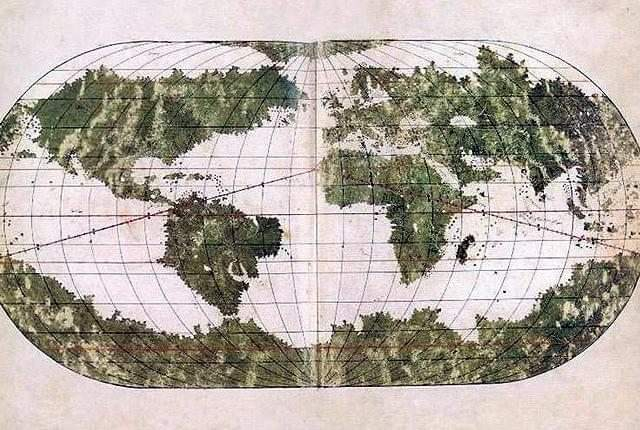
  • The Ottoman 16th Century Ali Macar Map (Ali Macar Reis'in Dünya Haritası)

    The Ali Macar Map is a striking example of 16th-century Ottoman cartography, created by the renowned Ottoman navigator Ali Macar Reis. This world map, dated to 1567, reflects the rich seafaring tradition of the Ottoman Empire and offers a unique perspective on global geography during the height of Ottoman naval power.

    The map illustrates:

    The Mediterranean Sea, the heart of the Ottoman maritime empire.
    Portions of Europe, Africa, and the Middle East, showing the regions the Ottoman Empire was directly or indirectly involved with.
    An artistic representation of world geography that reflects the knowledge of the time, with some areas detailed and others more speculative, reflecting global exploration.
    Ali Macar Reis’ map exemplifies the Ottoman Empire’s sophisticated understanding of navigation and geography, influenced by both Islamic and European cartographic traditions.

    #AliMacarMap #OttomanEmpire #16thCentury #OttomanCartography #WorldMaps #OttomanNavy #HistoricalMaps #OttomanHistory #AliMacarReis #GlobalExploration
    The Ottoman 16th Century Ali Macar Map (Ali Macar Reis'in Dünya Haritası) The Ali Macar Map is a striking example of 16th-century Ottoman cartography, created by the renowned Ottoman navigator Ali Macar Reis. This world map, dated to 1567, reflects the rich seafaring tradition of the Ottoman Empire and offers a unique perspective on global geography during the height of Ottoman naval power. The map illustrates: The Mediterranean Sea, the heart of the Ottoman maritime empire. Portions of Europe, Africa, and the Middle East, showing the regions the Ottoman Empire was directly or indirectly involved with. An artistic representation of world geography that reflects the knowledge of the time, with some areas detailed and others more speculative, reflecting global exploration. Ali Macar Reis’ map exemplifies the Ottoman Empire’s sophisticated understanding of navigation and geography, influenced by both Islamic and European cartographic traditions. #AliMacarMap #OttomanEmpire #16thCentury #OttomanCartography #WorldMaps #OttomanNavy #HistoricalMaps #OttomanHistory #AliMacarReis #GlobalExploration
    0 Σχόλια 0 Μοιράστηκε
Αναζήτηση αποτελεσμάτων