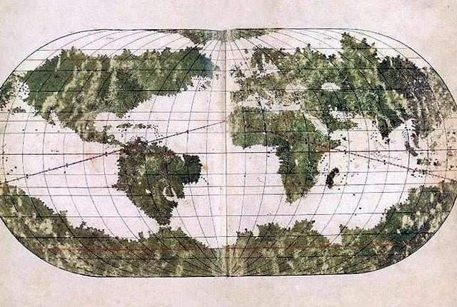
The Ottoman 16th Century Ali Macar Map (Ali Macar Reis'in Dünya Haritası)
The Ali Macar Map is a striking example of 16th-century Ottoman cartography, created by the renowned Ottoman navigator Ali Macar Reis. This world map, dated to 1567, reflects the rich seafaring tradition of the Ottoman Empire and offers a unique perspective on global geography during the height of Ottoman naval power.
The map illustrates:
The Mediterranean Sea, the heart of the Ottoman maritime empire.
Portions of Europe, Africa, and the Middle East, showing the regions the Ottoman Empire was directly or indirectly involved with.
An artistic representation of world geography that reflects the knowledge of the time, with some areas detailed and others more speculative, reflecting global exploration.
Ali Macar Reis’ map exemplifies the Ottoman Empire’s sophisticated understanding of navigation and geography, influenced by both Islamic and European cartographic traditions.
#AliMacarMap #OttomanEmpire #16thCentury #OttomanCartography #WorldMaps #OttomanNavy #HistoricalMaps #OttomanHistory #AliMacarReis #GlobalExplorationThe Ottoman 16th Century Ali Macar Map (Ali Macar Reis'in Dünya Haritası)
The Ali Macar Map is a striking example of 16th-century Ottoman cartography, created by the renowned Ottoman navigator Ali Macar Reis. This world map, dated to 1567, reflects the rich seafaring tradition of the Ottoman Empire and offers a unique perspective on global geography during the height of Ottoman naval power.
The map illustrates:
The Mediterranean Sea, the heart of the Ottoman maritime empire.
Portions of Europe, Africa, and the Middle East, showing the regions the Ottoman Empire was directly or indirectly involved with.
An artistic representation of world geography that reflects the knowledge of the time, with some areas detailed and others more speculative, reflecting global exploration.
Ali Macar Reis’ map exemplifies the Ottoman Empire’s sophisticated understanding of navigation and geography, influenced by both Islamic and European cartographic traditions.
#AliMacarMap #OttomanEmpire #16thCentury #OttomanCartography #WorldMaps #OttomanNavy #HistoricalMaps #OttomanHistory #AliMacarReis #GlobalExploration