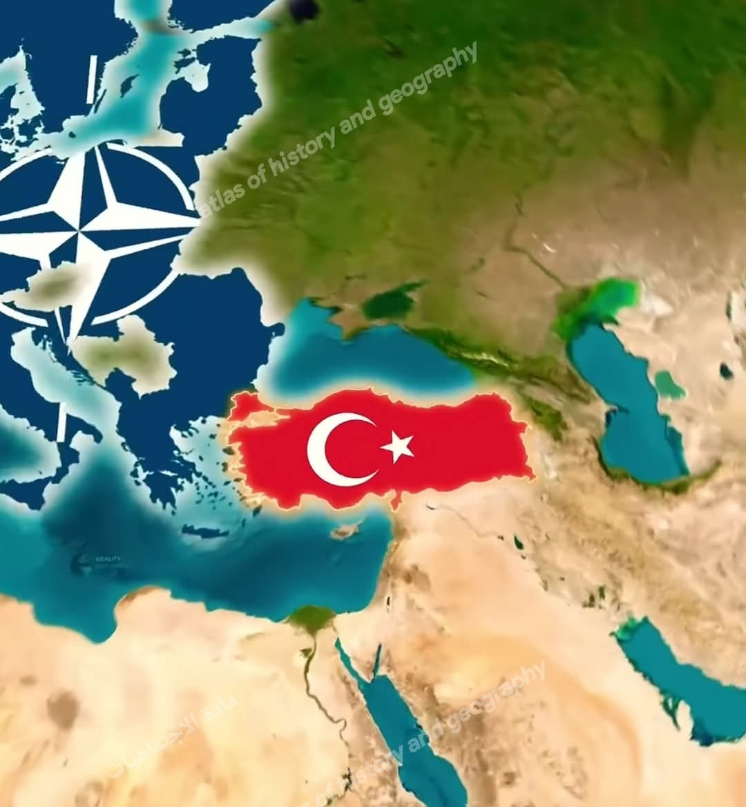
#Turkey is located at the crossroads of Asia and Europe. It is bordered by Greece and Bulgaria to the northwest, the Black Sea to the north, Georgia to the northeast, Armenia, the Azerbaijani exclave of Nakhchivan, and Iran to the east, Iraq to the southeast, Syria and the Mediterranean Sea to the south, and the Aegean Sea to the west.
Area: 783,562 square kilometers.
Topography: Includes the Taurus Mountains in the south, the Pontic Mountains in the north, fertile plains like the Anatolian Plain, and the Central Anatolian Plateau, along with lakes such as Lake Van.
Water Bodies: Borders four major seas: the Black Sea, the Sea of Marmara, the Aegean Sea, and the Mediterranean Sea.
2. Climate:
Coastal Areas:
Mediterranean and Aegean Coasts: Mediterranean climate with hot, dry summers and mild, wet winters.
Black Sea Coast: Moderate and humid climate year-round.
Inland Regions: Continental climate with hot, dry summers and very cold, snowy winters.
Climate Change: Turkey faces challenges like drought and rising temperatures due to climate change.
3. Population:
Population Size: Approximately 84.5 million (2021).
Population Distribution: Istanbul is the largest city with over 15.5 million residents. Ankara is the second largest, followed by Izmir, Bursa, and Antalya.
Ethnic Diversity: Predominantly Turks, with a significant Kurdish minority, and smaller Armenian, Arab, and Greek communities.
Population Growth: About 1.2% annually.
4. Economy:
GDP: Approximately $7.209 trillion in 2021.
Exports: Includes agricultural products, automobiles, textiles, and electronics, valued at $225 billion.
Imports: Mainly energy and raw materials, totaling $271 billion.
Unemployment Rate: Around 10.3%.
Agriculture and Industry: Notable for wheat, hazelnuts, and olives, as well as being a leading producer of automobiles and steel.
5. Currency:
The official currency is the Turkish Lira (TRY), which experiences fluctuations in value against foreign currencies.
6. Tourism:
Visitor Numbers: Turkey welcomed around 30 million tourists in 2021.
Revenue: Approximately $24.5 billion.
Top Destinations:
Istanbul: Iconic landmarks like Hagia Sophia, the Blue Mosque, and Topkapi Palace.
Antalya: A hub for coastal tourism.
Cappadocia: Known for its unique landscapes and hot air balloons.
Historical Sites: Ephesus and Troy.
7. History:
Civilizations: Turkey has been home to various civilizations, including the Hittites, Persians, Romans, and Byzantines.
Ottoman Era: Spanned from the 14th century to the early 20th century.
Modern Republic: Established in 1923 under Mustafa Kemal Atatürk, who moved the capital to Ankara and initiated widespread reforms.
8. Education:
Education System: Mandatory for 12 years (6 years primary, 3 years middle, 3 years secondary).
Higher Education: Home to numerous universities, including Istanbul University and Middle East Technical University.
Literacy Rate: Approximately 96%.
9. Healthcare:
Healthcare System: Turkey has a well-developed healthcare system encompassing public and private sectors.
Medical Tourism: A popular destination for medical and cosmetic treatments, attracting thousands of patients annually.
Hospitals: Equipped with state-of-the-art medical technology.
10. Culture:
Official Language: Turkish.
Religion: Islam is the predominant religion, with Christian and Jewish minorities.
Traditions: A blend of Eastern and Western cultural influences.
Turkey serves as a bridge between East and West, with a rich history and modern development.
#Turkey is located at the crossroads of Asia and Europe. It is bordered by Greece and Bulgaria to the northwest, the Black Sea to the north, Georgia to the northeast, Armenia, the Azerbaijani exclave of Nakhchivan, and Iran to the east, Iraq to the southeast, Syria and the Mediterranean Sea to the south, and the Aegean Sea to the west.
Area: 783,562 square kilometers.
Topography: Includes the Taurus Mountains in the south, the Pontic Mountains in the north, fertile plains like the Anatolian Plain, and the Central Anatolian Plateau, along with lakes such as Lake Van.
Water Bodies: Borders four major seas: the Black Sea, the Sea of Marmara, the Aegean Sea, and the Mediterranean Sea.
🌐 2. Climate:
Coastal Areas:
Mediterranean and Aegean Coasts: Mediterranean climate with hot, dry summers and mild, wet winters.
Black Sea Coast: Moderate and humid climate year-round.
Inland Regions: Continental climate with hot, dry summers and very cold, snowy winters.
Climate Change: Turkey faces challenges like drought and rising temperatures due to climate change.
🌐 3. Population:
Population Size: Approximately 84.5 million (2021).
Population Distribution: Istanbul is the largest city with over 15.5 million residents. Ankara is the second largest, followed by Izmir, Bursa, and Antalya.
Ethnic Diversity: Predominantly Turks, with a significant Kurdish minority, and smaller Armenian, Arab, and Greek communities.
Population Growth: About 1.2% annually.
🌐 4. Economy:
GDP: Approximately $7.209 trillion in 2021.
Exports: Includes agricultural products, automobiles, textiles, and electronics, valued at $225 billion.
Imports: Mainly energy and raw materials, totaling $271 billion.
Unemployment Rate: Around 10.3%.
Agriculture and Industry: Notable for wheat, hazelnuts, and olives, as well as being a leading producer of automobiles and steel.
🌐 5. Currency:
The official currency is the Turkish Lira (TRY), which experiences fluctuations in value against foreign currencies.
🌐 6. Tourism:
Visitor Numbers: Turkey welcomed around 30 million tourists in 2021.
Revenue: Approximately $24.5 billion.
Top Destinations:
Istanbul: Iconic landmarks like Hagia Sophia, the Blue Mosque, and Topkapi Palace.
Antalya: A hub for coastal tourism.
Cappadocia: Known for its unique landscapes and hot air balloons.
Historical Sites: Ephesus and Troy.
🌐 7. History:
Civilizations: Turkey has been home to various civilizations, including the Hittites, Persians, Romans, and Byzantines.
Ottoman Era: Spanned from the 14th century to the early 20th century.
Modern Republic: Established in 1923 under Mustafa Kemal Atatürk, who moved the capital to Ankara and initiated widespread reforms.
🌐 8. Education:
Education System: Mandatory for 12 years (6 years primary, 3 years middle, 3 years secondary).
Higher Education: Home to numerous universities, including Istanbul University and Middle East Technical University.
Literacy Rate: Approximately 96%.
🌐 9. Healthcare:
Healthcare System: Turkey has a well-developed healthcare system encompassing public and private sectors.
Medical Tourism: A popular destination for medical and cosmetic treatments, attracting thousands of patients annually.
Hospitals: Equipped with state-of-the-art medical technology.
🌐 10. Culture:
Official Language: Turkish.
Religion: Islam is the predominant religion, with Christian and Jewish minorities.
Traditions: A blend of Eastern and Western cultural influences.
Turkey serves as a bridge between East and West, with a rich history and modern development.

0 Commentaires
0 parts